
Scanning The Snow From The Sky
Planes, lasers will provide critical data to water managers statewide.
By Jay Adams
If you want to know about the snow, the sky is the limit when it comes to collecting data about the mountain snowpack.
That’s why Denver Water, the Colorado Water Conservation Board and other water providers across the state are investing in a high-tech program to measure snowpack using lasers from a plane.
And in mid-May, Colorado Gov. Jared Polis signed a bill to formally incorporate the program into the Colorado Water Conservation Board. The board’s mission is to conserve, develop, protect and manage Colorado's water for present and future generations.
Monitoring the mountain snowpack is critical for Denver Water because once the snow melts, it becomes the water supply for the 1.5 million people the utility serves in Denver and surrounding suburbs.
Traditionally, Denver Water has tracked the snowpack by sending crews to collect and measure snow samples on the ground and monitoring data from automated backcountry weather stations called SNOTELs.
In 2019, to help improve water supply forecasts, Denver Water began working with Airborne Snow Observatories Inc., or ASO for short, to gain a fuller picture of the snowpack. The company uses advanced technology developed at NASA to measure the snowpack that's built up across entire watersheds.
"Getting this high-tech information about the snowpack from ASO before the snow starts to melt improves the accuracy of our spring runoff and water supply forecasts for the coming year,” said Nathan Elder, Denver Water’s manager of water supply.
“Having the ASO information in the spring helps us manage our water resources and gives us a better idea of if we’ll need to have watering restrictions for our customers in the summer. The data also gives us a very good idea of how the spring runoff in the rivers could impact aquatic habitat and recreation.”
Space Age Tech
ASO planes fly with two key pieces of technology and equipment onboard: a lidar and an imaging spectrometer.
The spectrometer measures how much solar energy is reflected by the snow. This information is used to help determine how fast the snowpack will melt.
Lidar, which stands for light detection and ranging, uses beams of light to measure distance. To determine snow depth, the plane flies over a watershed in the summer and uses lidar to scan the earth’s surface when it's free of snow.
Then in the spring, when the landscape is covered with snow, the ASO team flies over the same territory again and measures the distance from the plane to the snow surface below. By comparing the differences in elevation, the ASO team can accurately calculate the depth of the snow.
Digging It Old School
To supplement the data collected from the plane, ASO also incorporates three “old-school” sources of data. It uses information collected by automated weather stations called SNOTELs, from snow samples collected and measured by crews at predetermined locations in watersheds, and data from samples collected by the ASO team or partners from snow pits dug in the same watersheds the plane flies over.
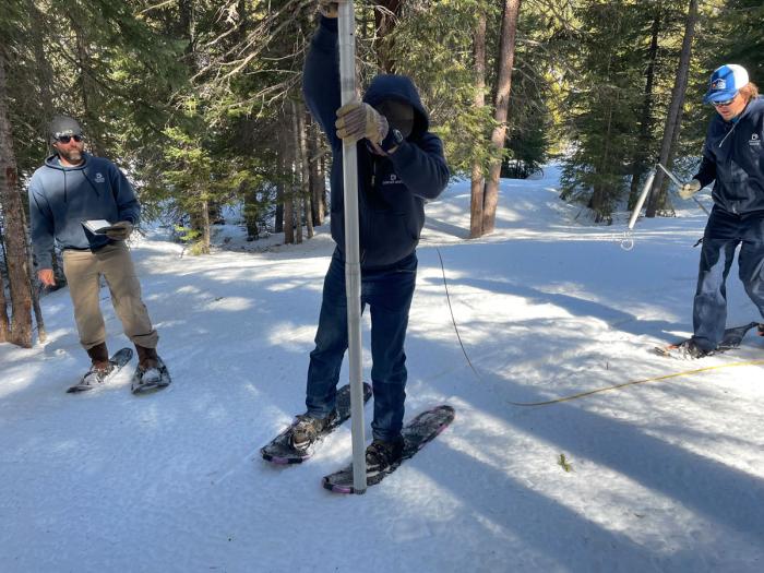
Denver Water crews use a special tube to gather snow samples near Winter Park as part of pre-set snow courses. ASO uses these ground measurements to supplement data collected from the planes to determine how much water is in a watershed. (Credit: Denver Water)
This ground-based data helps to verify the airborne snow-depth measurements. The ground data also provides snow density information, which is used to calculate the volume of water in the snowpack, called the snow water equivalent, or SWE.
“We’re able to use the traditional methods in combination with our next generation technology to measure the mountain snowpack to an accuracy that has never before been possible,” said Jeffrey Deems, ASO's co-founder.
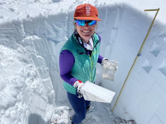
Cara Piske, an ASO operations scientist, collects a sample of snow from a pit dug in Mayflower Gulch near Copper Mountain in Summit County. The sample is weighed to determine its density, which is used to calculate the amount of water frozen in the snow, called the snow water equivalent. (Credit: Denver Water)
Deems said the data from the ASO flights is incredibly valuable because the plane can accurately measure the snow across an entire watershed and at high elevations that don’t have automated weather stations and are inaccessible to people.
In 2023, ASO flew over eight regions in Colorado (including Denver Water’s watersheds in the Upper South Platte, Blue, Fraser and South Boulder Creek river basins.)
During the first set of flights in April, which aimed to capture the peak snowpack, the ASO team calculated that there was 108,000 acre-feet of water packed into the snow in the Upper South Platte Basin, 175,000 acre-feet of water in the Blue River Basin which feeds into Dillon Reservoir, and 104,000 acre-feet of water in Denver Water’s Moffat Collection System located in the Fraser River Basin.
A second round of flights were conducted in late May and early June to capture any new snow and to see how fast the snow melted.
Elder said the ASO snowpack estimates in 2023 turned out to be a very strong prediction of the actual streamflow during that year’s spring runoff.
“Having ASO really helps reduce uncertainty and improve decision making for our water planning, and each flight uncovers new insight into the snowpack that is otherwise unmeasurable,” Elder said. “Our first charge is to ensure we have an adequate water supply for our customers, and the sooner we can make that determination the better.”
Having the additional data helps water planners because traditional snowmelt forecasts can have significant errors or wide ranges, which makes it more challenging to manage water supplies.
Building A Statewide Program
Recognizing the value of building a statewide ASO effort, in 2021, Denver Water helped coordinate and develop the Colorado Airborne Snow Measurement program or CASM.
The CASM program includes agricultural and municipal water providers such as Denver Water, as well as environmental groups and nonprofits with support from the Colorado Water Conservation Board and federal agencies.
In 2025, Colorado Gov. Jared Polis signed H.B. 1115 into law, which formally integrated the CASM program into the Colorado Water Conservation Board. The bill created a dedicated staff member to administer the program to help coordinate ASO flights, distribute data and manage funding statewide.
"Having accurate water supply data helps all water users,” said Taylor Winchell, climate adaptation specialist at Denver Water. “Our goal with CASM has always been to create a sustainable statewide program, and this new legislation is a major step in making that goal a reality.”
The Colorado Water Conservation Board will formally coordinate CASM’s planning team, which includes Denver Water, Colorado River District, San Luis Valley Water Conservancy District, Northern Water, St. Vrain & Left Hand Water Conservancy District, Upper Gunnison Water Conservancy District, and the Dolores Water Conservancy District, along with ASO and LRE Water.
Benefits Today And Tomorrow
Winchell said one of the big benefits of the ASO flights is that the data is available within a few days of collecting it, so water managers have a better estimate of how much water supply they’ll have for the coming year — and when to expect the water to end up in mountain streams.
The other benefit is having a wealth of high-quality data covering thousands of square miles to monitor the effects of climate change.
“As our snowpack changes with the changing climate, being better able to measure that snowpack becomes more important as more snow falls as rain, as the timing of the spring melt changes and as snow falls at ever-higher elevations because of warming,” Winchell said.
“We can’t rely as much on historical snowpack datasets to understand the new snowpack reality.”
ASO, which also conducts data collection flights in California, Wyoming, Oregon and internationally, also continues to develop its technology and modeling to help water providers get the information they need.
“We're really proud of what we’re doing,” Deems said. “We love the snow and feel like we're making a difference in helping our society better understand our mountain snowpack reservoir.”
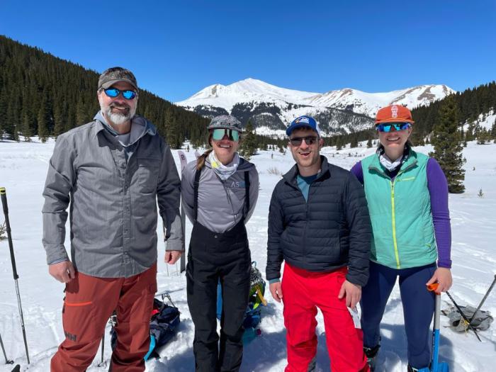
Members of the ASO team, (left to right) Jeffrey Deems, Kate Burchenal and Cara Piske, teamed up with Denver Water’s Taylor Winchell (in the black jacket) to dig a snow pit in Summit County. (Credit: Denver Water)